


 Instagram
 YouTube
Flood Zone
Expert contributes to two national reports on impact of climate change on transportation
April 1, 2008
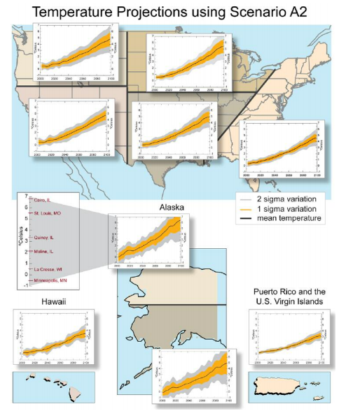
Climate model projections of surface air temperature (in Centigrade) and their associated uncertainties for a business as usual future scenario with little reduction of human-produced greenhouse gas emissions.
Climate change is expected to lead to flooding of roads, railways, airport runways and other transit systems in the United States, according to two recent national reports that were co-authored by CRD climate modeling expert Michael Wehner.
Though the impacts of climate change will vary by region throughout the United States, it is certain they will be widespread and costly in human and economic terms. It also will require significant changes in the planning, design, construction, operation, and maintenance of transportation systems, according to the first report, “The Potential Impacts of Climate Change on U.S. Transportation,” published by the National Research Council. The second report, “Climate Change and Variability on Transportation Systems and Infrastructure: Gulf Coast Study, Phase I,” issued by the U.S. Department of Transportation, focuses on the impact on 48 contiguous counties in four states, from Galveston, Texas to Mobile, Alabama.
”Global warming is very likely to have serious impacts on many aspects of society, some with high economic costs. The transportation sector is just one of these,” Wehner said. “Our reports are intended to give government planners the information they need to make the difficult decisions which will be necessary to adapt to these almost certain impacts.”
Throughout the country, transportation planners and engineers use historical temperature and precipitation data to help them design transportation systems that can withstand local weather and climate conditions. Both reports find that those climate predictions may no longer be reliable, however, in the face of new weather and climate extremes. Roads, transit systems and airports that were built based on older data could fail as a result.
The first report looks at the impact across the United States and its territories and finds that California airports in San Francisco, Santa Barbara, and Oakland could be inundated under conditions of extreme high tides coupled with flood conditions and exacerbated by local sea-level rise. In the Bay Area, major highways and railroads near sea level could also be threatened by rises in sea level. Not all climate changes will be negative, however. Marine transportation could benefit from more open seas in the Arctic, creating new and shorter shipping routes and reducing transport time and costs. In cold regions, rising temperatures could reduce the costs of snow and ice control and would make travel conditions safer for passenger vehicles and freight.
The report draws upon five papers commissioned by the Transportation Research Board, which, like the National Research Council, is part of the National Academies. One of the papers, “Climate Variability and Change with Implications for Transportation,” was co-authored by Thomas C. Peterson, Marjorie McGuirk and Tamara G. Houston of the National Oceanographic and Atmospheric Administration’s (NOAA) National Climatic Data Center, Andrew H. Horvitz of NOAA’s National Weather Service and Wehner.
The second report, focusing on the Gulf Coast, provides an assessment of the vulnerabilities of transportation systems in the region to potential changes in weather patterns and related impacts, as well as the effect of natural land subsidence and other environmental factors in the region. The authors of the study in the region. The authors of the study find that changes in climate could disrupt transportation services in the region. Twenty-seven percent of major roads, 9 percent of rail lines and 72 percent of area ports could be vulnerable to flooding due to future sea level rise.
For both reports, Wehner and his co- authors first analyzed observed climate data (daily temperature and precipitation) from 1950 to 2005. Then they used the large collection of climate model data, archived at the Program for Climate Model Diagnosis and Intercomparison (PCMDI) at Lawrence Livermore National Laboratory, to validate the models against observations and to create plausible projections of future climate change relevant to transportation analysts. They considered future scenarios ranging from very aggressive reduction of human-produced greenhouse gas emissions to none at all. The simulation data, based on 25 cli- mate models, reflect the climate research community’s collective efforts to predict the global climate of the future.
The simulations took into account different factors based on economical, technological, and sociological assumptions. Researchers from the U.S., Norway, Canada, France, Australia, Russia, Germany, Korea, China, Japan and the United Kingdom contributed to the collection at PCMDI. The Intergovernmental Panel on Climate Change (IPCC) used these data for its Fourth Assessment Report released last year, a comprehensive document that won the IPCC a share of the 2007 Nobel Peace Prize.
About Computing Sciences at Berkeley Lab
High performance computing plays a critical role in scientific discovery. Researchers increasingly rely on advances in computer science, mathematics, computational science, data science, and large-scale computing and networking to increase our understanding of ourselves, our planet, and our universe. Berkeley Lab’s Computing Sciences Area researches, develops, and deploys new foundations, tools, and technologies to meet these needs and to advance research across a broad range of scientific disciplines.