


 Instagram
 YouTube
Collaboration Charts New Course for Future of Field Research Data
5G Connectivity Gives Scientists Better Access to Data on Atmospheric Processes in Colorado Mountains
February 2, 2022
By Elizabeth Ball
Contact: cscomms@lbl.gov
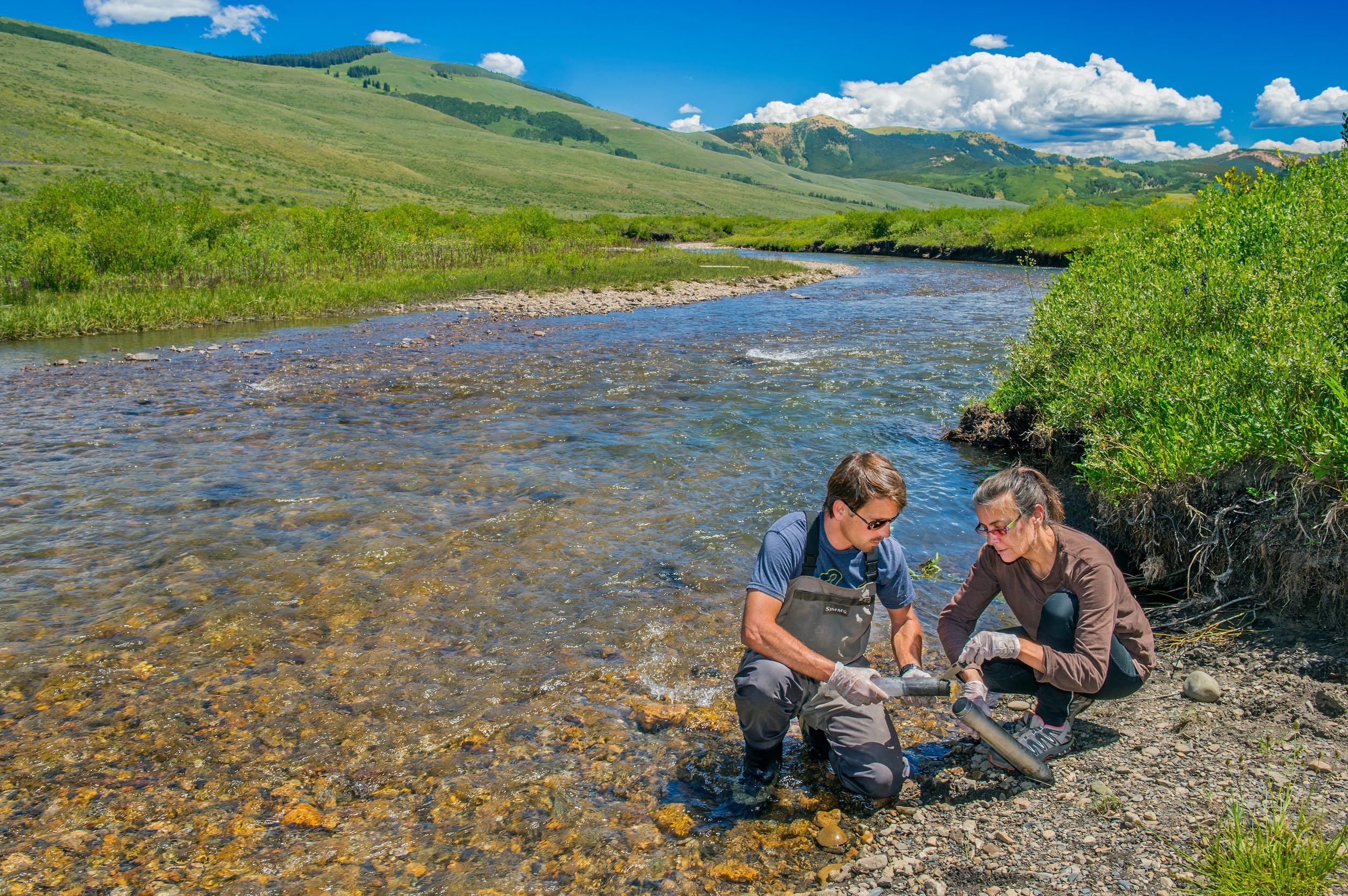
The East River watershed has become a living field laboratory for scientists to better understand how vital mountainous watersheds throughout the world are responding to environmental change. (Credit: Roy Kaltschmidt, Berkeley Lab)
As winter falls in a remote corner of Colorado, in a mountainous watershed on the Upper Colorado River, hundreds of sensors continue their work, day in and day out: forming a detailed quantitative picture of the watershed by collecting data on dozens of metrics on how it collects water from the atmosphere and retains and releases that water downstream.
Field research is an essential tool in environmental science; even so, retrieving and moving data from remote locales, ensuring that instruments are collecting data in spite of harsh conditions, and making data available for analysis and modeling has been a persistent challenge. But in one field lab, new investments in local 5G connectivity and remote satellite data backhaul — spearheaded by the U.S. Department of Energy’s (DOE) Energy Sciences Network (ESnet), headquartered at Lawrence Berkeley National Laboratory (Berkeley Lab) — is providing a high-tech road map for the future of data in field research.
In the East River watershed in southwestern Colorado, scientists funded by the DOE are leading ambitious multi-program and multi-agency activities to advance scientific understanding of how processes in the atmosphere, surface, and sub-surface work together to impact the dwindling amount of water produced by the Colorado River. The study area is the primary field site of Berkeley Lab’s Watershed Function Scientific Function Area (Watershed SFA), which has been leading studies in the watershed since 2014. The Watershed SFA seeks to understand and predict how disturbances such as drought and early snowmelt will impact the quantity and quality of water in mountain watersheds.
The DOE has committed to a wide-ranging set of science and data activities by collecting “bedrock-to-atmosphere” data on the dominant physical, chemical, and biological processes that impact water resources. By measuring meteorology, snowpack, vegetation, streamflow, and water quality, this experiment is offering an unprecedented and comprehensive look at the mechanisms of a basin that ultimately provides water for more than 40 million people.
Toward this end, starting in 2021, a new DOE-funded field research campaign known as the Surface Atmosphere Integrated Laboratory (SAIL) began collecting additional observations on atmospheric processes in these mountains. SAIL is conducted by the DOE Atmospheric Radiation Measurement (ARM) user facility; Los Alamos National Laboratory leads the overall management and operations of the ARM mobile observatory for SAIL. As part of the Watershed Function SFA project, SAIL leverages the substantial efforts that Berkeley Lab has already undertaken in this area, bringing together a wide range of scientific disciplines to create the world’s first bedrock-to-atmosphere mountain integrated field laboratory.
“The SAIL campaign represents a new mode of doing science in the Rocky Mountains, where we bring the atmospheric scientists together with the surface and subsurface researchers to take a holistic view of how water actually flows through mountains and is delivered downstream to users,” said SAIL campaign principal investigator Dan Feldman, a staff scientist in the Earth and Environmental Sciences Area (EESA) at Berkeley Lab.
5G Connectivity Opens New Doors
The East River field laboratory consists of many different types of sensors spread across the watershed, which collectively yield enormous amounts of data. In some cases the data can be retrieved using a 3G cell phone connection, but often scientists have to manually download data onto their computers from memory cards or data loggers.
“Network connectivity through cellphones can be spotty across the watershed, and slow,” said Charuleka Varadharajan, an EESA research scientist who in December was named the first lead for EESA’s new Earth AI & Data program domain. “Driving around to download data can be a big challenge in a huge, mountainous watershed, where conditions may make it impossible to access all those sites, particularly in winter. It would be exciting to have high-speed connectivity since it would allow us to retrieve data without having to access the sensors and detect potential problems much sooner than is currently possible.”
The collaboration between ESnet and EESA is intended to address this challenge. Private wireless, including 5G connectivity at the local level, will allow sensors to communicate with each other, while remote data backhaul makes it possible for them to transmit data out of the area. This wireless connectivity is made possible by a recently opened segment of the electromagnetic spectrum supporting Citizens Broadband Radio Service, which allows entities like ESnet to install private wireless service anywhere in the U.S. they can deploy a radiohead. This dramatically expands the accessibility of high-speed wireless connection in remote areas; as a test case, the East River project represents the possibilities of wireless connection for other environmental science projects in remote areas.

During the SAIL campaign, instruments on the tower will measure core variables related to surface meteorology and collect radiation data to help determine the site’s surface energy balance. (Credit: John Bilberry, Los Alamos National Lab)
“If we do this right, we can deploy radioheads when scientists need to backhaul field data,” said ESnet computer systems engineer Andrew Wiedlea. “There’s a lot of scientific data collection occurring in the field, and this extends our reach to be able to serve those communities. Wireless is also becoming key to what’s happening at facilities, so it’s a big part of expanding to meet scientific needs of the future.”
On the ground, the high-speed network between the sensors will allow scientists to collect more and better-quality data. “For the SAIL project, they're deploying a few radars at the site — one on Crested Butte Mountain and another 20 miles away,” said sensor developer Stijn Wielandt. “Basically what we are trying to do is connect those radars to the Internet so that they can talk to each other. By enabling that connectivity, you can get way more information out of them because they can coordinate their measurements.”
Additional science is enabled by the coordination of the two radars: a single radar collects precipitation measurements, while multiple radars drive deeper insights into precipitation formation not just by collecting measurements of precipitation but by allowing scientists to reconstruct how air flows over mountains and triggers precipitation.
An Expansive Vision
What to do with all that high-quality data? In a collaboration with SpaceX, East River systems will transmit data from the watershed via a constellation of SpaceX satellites, known as Starlink, in low-Earth orbit. The data will travel to a Starlink network point of presence in Seattle and then on to ESnet. From there data will flow into different data systems and eventually be made public for download through the DOE ARM data portal and the Environmental Systems Science Data Infrastructure for a Virtual Environment (ESS-DIVE) repository.
This investment in data gathering and transmission is a leap forward for the East River field site specifically, but it also illuminates the future of the role of computing in field research more generally, in which data may flow back and forth between the field and the laboratory. Eventually, real-time data from the field will inform and refine models even as the needs and monitoring of models inform and refine data gathering in the field.
“A long-term vision is the co-development of models with data, observations, and theory,” said Varadharajan. “We want to be able to collect data when and where it’s essential for us to improve our scientific understanding and predictions for how the world works. Ideally, advanced networking will not only make it easier to get data from the field, but also enable our computational systems to be running models with near real-time data and directing new observations at places and times where there is greatest uncertainty. We envision that the two-way communication between the models and the sensor instrumentation will help us make more intelligent decisions about how to observe the world.”
Likewise, ESnet involvement in the SAIL campaign is a step toward seamless data transmission from anywhere — an expansive vision of intelligent and efficient data transfer.
“For the teams working to connect the sensors in the field and transmit the data to other facilities, the combination of networking approaches is the challenge of a career,” said Wiedlea. “But to ESnet users, the beauty of these advances is that the system just works. We’re expanding ESnet in such a way that the user can transfer data seamlessly from the field without needing to know the details, whether it’s wireless or optical, or satellite. ESnet is going where the science is going.”

In this view of the Upper Colorado River Basin, you can see numerous ways in which the atmosphere and surface interact in complex terrain; for example, the mountains and clouds impact sunlight, while the mountains also shape cloud formation and dissipation. (Credit: Roy Kaltschmidt, Berkeley Lab)
For more information and images, visit this Berkeley Lab photo story, "Mountains of Data: An Unprecedented Climate Observatory to Understand the Future of Water."
About Computing Sciences at Berkeley Lab
High performance computing plays a critical role in scientific discovery. Researchers increasingly rely on advances in computer science, mathematics, computational science, data science, and large-scale computing and networking to increase our understanding of ourselves, our planet, and our universe. Berkeley Lab’s Computing Sciences Area researches, develops, and deploys new foundations, tools, and technologies to meet these needs and to advance research across a broad range of scientific disciplines.